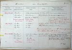
| < | List of Names as written on the Plan |
Various modes of Spelling the same Names |
Authority for those modes of Spelling |
Situation | Descriptive Remarks, or other General Observations which may be considered of Interest |
> |
|---|---|---|---|---|---|---|
| Blanchland | Blanchland | MacKenzie’s History of the County | 53 chains South | A neat compact village north of | ||
| Blanchland | Whites Directory | West of Cowbyers | the river Derwent, |
|||
| Blanchland | Estate plan of Shotley Det. | a deep vale completely surrounded by | ||||
| Blanchland, or Alba Landa | White"s Directory | moors. Contains St M. Church | ||||
| Blanchland | Co Map | (District Ch.), School, PO | ||||
| Parsonage, Inns etc etc. | ||||||
| Bog Wood | Bog Wood | Mr Hutchinson | 16 chains South | A large mixed wood at the east | ||
| Bog Wood | Mr Iley | East |
extremity of Low Haugh | |||
| Bog Wood | Mr Oliver | |||||
| This point ofJunction is on 108/11 Space 47 | ||||||
| also on 16/3 Hunstanworth, Durham. | ||||||
| River Derwent | River Derwent | Estate Plan of Newbiggin | 25 chains south | A |
||
| River Derwent | Rev J Gibson | east of Cowbyers | considerable river commencing at the | |||
| River Derwent | Mr Iley | junction of Beldon and Knucton Burns, flowing in | ||||
| River Derwent | White"s Directory | |||||
| River Derwent | Co Map | an easterly direction past Blanchland and falling | ||||
| into the Tyne at Derwent Haugh. | ||||||
| Not navigable – not tidal | ||||||
| on these plans. | ||||||
| John Kelly Civil Assistant | ||||||
Abbreviations are underlined like this RE and the expansion may be seen by hovering the cursor over the abbreviation.
| An entry outlined like this has a note which may be seen by hovering the cursor over it. |
Transcribed by TH
Return to Shotley index