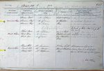
| < | List of Names as written on the Plan |
Various modes of Spelling the same Names |
Authority for those modes of Spelling |
Situation | Descriptive Remarks, or other General Observations which may be considered of Interest |
> |
|---|---|---|---|---|---|---|
| Ancient pack horse roads have always been looked upon at OMO | ||||||
| as antiquities – as much so as Roman Roads – and the name | ||||||
| is in German text on plans of Lancashire & Yorkshire – but | ||||||
| if this road was used only for the Lead mine – it may not be an Antiquity o.m.o. | ||||||
| Carriers’ Way | Carriers’ Way | Mr Stephenson | South and Adjoining | An old road formerly used by | ||
| Carriers’ Way | Mr Davison | to Blackburn | the Carriers who brought lead ore | |||
| Carriers’ Way | Mr Sanderson | Head | on the backs of ponies, from Allen- | |||
| dale to a smelting mill near Dukes Fell in | ||||||
| the Parish of Slaley. Used only for the | ||||||
| lead mines. | ||||||
| Black Burn | Black Burn | Mr Stephenson | Runs in a North | A small stream rising on | ||
| Black Burn | Mr Sanderson | Westerly direction | ||||
| Black Burn | Mr Davison | from Blackburn | northerly direction into the Devil"s Water. | |||
| Head | ||||||
| Round Hill | Round Hill | Mr Sanderson | 37 chains South | A conspicuous hill of a | ||
| Round Hill | Mr Davison | West of Blackburn | round form it is the highest | |||
| Round Hill | Mr Stephenson | Head | land in the township of Newbiggin | |||
| John Kelly Civil Assistant | ||||||
Note: No Parish name
Abbreviations are underlined like this RE and the expansion may be seen by hovering the cursor over the abbreviation.
| An entry outlined like this has a note which may be seen by hovering the cursor over it. |
Transcribed by TH
Return to Shotley index