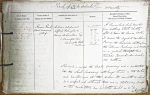
| < | List of Names as written on the Plan |
Various modes of Spelling the same Names |
Authority for those modes of Spelling |
Situation | Descriptive Remarks, or other General Observations which may be considered of Interest |
> |
|---|---|---|---|---|---|---|
| Roman Road | Roman Road | Chalmers Caledonia | on sheets | A Roman Road which branches | ||
| (Devil’s Causeway) | (Devil’s "Causeway") | from Watling Street shortly | ||||
| (Site of) | (Site of) | 7.1 | after it leaves the Roman Wall. | |||
| Roman Road | Jeffrey’s Roxburghaire | 7.5 | It crosses the Coquet at Brinkburn | |||
| Roman Road | Henry McLauchlan Esq | 7.9 | Priory, the Alne below Whittingham, | |||
| 3 Kennington Road | 7.13 & | the Till near Fowberry; and proceeds | ||||
| Kennington Park | 11.11 | in a general straight line | ||||
| London | towards Berwick-upon-Tweed | |||||
| old Castle | ||||||
| This road is named the Devil’s Causeway, and is constructed | ||||||
| like the Wheel Causeway, with large stones in the centre, | ||||||
| and smaller ones at the sides. Its breadth is about | ||||||
| 21 or 22 feet, and although there are no stationary camps | ||||||
| on this road there can be little doubt as to its antiquity | ||||||
| W. Beatty | ||||||
Note: Signature in header
Abbreviations are underlined like this RE and the expansion may be seen by hovering the cursor over the abbreviation.
| An entry outlined like this has a note which may be seen by hovering the cursor over it. |
Transcribed by CC and SMH
Return to Holy Island index