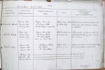
| < | List of Names as written on the Plan |
Various modes of Spelling the same Names |
Authority for those modes of Spelling |
Situation | Descriptive Remarks, or other General Observations which may be considered of Interest |
> |
|---|---|---|---|---|---|---|
| Brownrig Head | Brownrig Head | Edward Lawson Esq | About 29 chains |
A hill of considerable elevation which forms the | ||
| Brownrig Head | Mr Edward Fletcher | of Gorlees Crag | dividing ridge between the parishes of Elsdon | |||
| Brownrig Head | Mr John Fletcher & Parish Plan | and Bellingham | ||||
| Gorlees Crag | Gorlees Crag | Edward Lawson Esq | About 29 chains SW | A rocky precipice consisting of loose stones and | ||
| Gorlees Crag | Mr Edward Fletcher | of Brownrig Head | extending into the adjoining parish origin of | |||
| Gorlees Crag | Mr John Fletcher | name unknown | ||||
| Award and Parish Plan | ||||||
| Andrews Pike | Andrews Pike | Mr Edward Fletcher | About 35 chains N | A pile of rough stones about 8 feet high taking | ||
| Andrews Pike | Mr Nichols | of Brownrig Head | its name from the person who erected it | |||
| Andrews Pike | Mr John Fletcher | |||||
| Rooking Moor | See Name Book of S. 51 – P. 5 | |||||
| Cleughbrae Moor | See Name Book of S. 51 – P. 6 | |||||
| Brownrig Common | See Name Book of S. 51 – P. 10 | |||||
| Edw. Gillespie Sapper Royal Engineers |
Abbreviations are underlined like this RE and the expansion may be seen by hovering the cursor over the abbreviation.
| An entry outlined like this has a note which may be seen by hovering the cursor over it. |
Transcribed by CC
Return to Elsdon 364 index