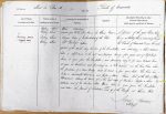
| < | List of Names as written on the Plan |
Various modes of Spelling the same Names |
Authority for those modes of Spelling |
Situation | Descriptive Remarks, or other General Observations which may be considered of Interest |
> |
|---|---|---|---|---|---|---|
| Watling Street | Watling Street | Whites Directory | 62 Chains East | A portion of the great Roman Road | ||
| ROMAN ROAD | Watling Street | Extracts from McLauchlins Memoir | of the Peel | known as Watling Street, extending [through] | ||
| (Remains of) | Watling Street | Hodgson’s History of Northumberland | the Parish of Corsenside it enters the north | |||
| Watling Street | Dr Routlidge Highleam | |||||
| portion of the parish along the line of the Turnpike and extending a short distance | ||||||
| takes a slight curve to the east and passing twenty five yards east of Dykehead | ||||||
| house, it again joins the Turnpike, and proceeding along it for some distance leaves | ||||||
| it again at Woodhouse and proceeding in a S.W. direction over the River Reed [sic] where | ||||||
| the foundation of a stone Bridge could be traced a few years back. The Road here | ||||||
| takes a considerable |
||||||
| "Habitancum" shaping its course |
||||||
| distance west of the Fourlaws Public House when it again joins the Turnpike | ||||||
| and enters the parish of Chollerton |
||||||
| Alfred Brittain Sapper Royal Engineers | ||||||
Abbreviations are underlined like this RE and the expansion may be seen by hovering the cursor over the abbreviation.
| An entry outlined like this has a note which may be seen by hovering the cursor over it. |
Transcribed by EDA
Return to Corsenside index