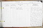
| < | List of Names as written on the Plan |
Various modes of Spelling the same Names |
Authority for those modes of Spelling |
Situation | Descriptive Remarks, or other General Observations which may be considered of Interest |
> |
|---|---|---|---|---|---|---|
| River Till | River Till | County Map | On Sheets | A river which has its rise in | ||
| Whites Directory | 14.11 | the Eastern flank of the Cheviot | ||||
| 14.12 | Hills, in the parish of Ilderton, | |||||
| about 4 miles South of Wooler. | ||||||
| From this point it proceeds in | ||||||
| a N. Easterly direction for about | ||||||
| 4 miles to Haggis Hall, where it | ||||||
| receives the waters of the River | ||||||
| Breamish: it then proceeds | ||||||
| Northerly for about 4 miles | ||||||
| to Lyham, at this point it turns | ||||||
| for about 4 miles to Westwood | ||||||
| Hall, where it receives the | ||||||
| Wooler Water – it then proceeds | ||||||
| in a generally N West direction | ||||||
| for about 2 miles, where it Receives | ||||||
| the waters of the River Glen, | ||||||
| which river is formed by | ||||||
| W. Beatty Civil Assistant |
Note: Signature in header
Abbreviations are underlined like this RE and the expansion may be seen by hovering the cursor over the abbreviation.
| An entry outlined like this has a note which may be seen by hovering the cursor over it. |
Transcribed by BFR and BER
Return to Wooler 434 index