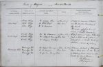
| < | List of Names as written on the Plan |
Various modes of Spelling the same Names |
Authority for those modes of Spelling |
Situation | Descriptive Remarks, or other General Observations which may be considered of Interest |
> |
|---|---|---|---|---|---|---|
| Pike Rigg | Pike Rigg | The Estate Plan | 40 Chains S.E. of | A ridge or eminence situated | ||
| (A.D. 1745) | Red Well | on the western boundary of | ||||
| Pike Rigg | B. Ord Esqr. | this Parish. | ||||
| Pike Rigg | Mr. M. Summers | The water shedding line of | ||||
| which forms part of the boundary. | ||||||
| Lord’s Rigg | Lord’s Rigg | Mr. M. Summers | 55 Chains S.E. of | A long narrow ridge extending | ||
| Lord’s Rigg | Mr. Stobbart Mainrigg | Red Well | from a little south of Blaeberry | |||
| (Farmer) | Cleugh in a South Westerly | |||||
| Lord’s Rigg | Mr. Summers Park Head | direction about 47 Chains. | ||||
| Lord’s Rigg | (Farmer) | |||||
| Mainsrigg Fell | Mainsrigg Fell | Mr. Stobbart Mainrigg | 12 Chains South of | A minor district of Whitfield | ||
| (Farmer) | Red Well | Moor bounded on the North | ||||
| Mainsrigg Fell | Mr. M. Summers | by Blaeberry Burn and on the | ||||
| Mainsrigg Fell | Mr. Lee. Farmer Morley Hill | South by Carr’s Burn. | ||||
| John Davison Sapper Royal Engineers |
Abbreviations are underlined like this RE and the expansion may be seen by hovering the cursor over the abbreviation.
| An entry outlined like this has a note which may be seen by hovering the cursor over it. |
Transcribed by PT
Return to Whitfield index