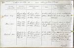
| < | List of Names as written on the Plan |
Various modes of Spelling the same Names |
Authority for those modes of Spelling |
Situation | Descriptive Remarks, or other General Observations which may be considered of Interest |
> |
|---|---|---|---|---|---|---|
| Hespie Crag | Hespie Crag | Mr George Lowes | 29 chains S. E. | Loose rocks on a steep Brae | ||
| Hespie Crag | Mr Robert Scott | of Dinner Bush. | at the south end of The | |||
| Hespie Crag | Mr John Robson | Dodd. | ||||
| Aldery Sike | Aldery Sike | Mr George Lowes | 60 chains S. | A small stream in High- | ||
| Aldery Sike | Mr Robert Scott | East of Dinner | field Moor flowing in a | |||
| Aldery Sike | Mr John Robson | Bush. | south-easterly direction to | |||
| Tarset Burn. So called | ||||||
| from the Alder trees which | ||||||
| formerly grew along it. Commonly called | ||||||
| Aller. | ||||||
| Highfield Moor | Highfield Moor | Mr George Lowes | In the N. West | A large district of unenclosed | ||
| Highfield Moor | Mr Robert Scott | of the Parish. | Moor land bounded on the | |||
| Highfield Moor | Mr John Robson | 59/2 | North by Hunter’s Burn, on the | |||
| Allery Sike | Mr Wm Rutherford | |||||
| boundary, on the south by Thorney- | ||||||
| burn Common. | ||||||
| M Costelloe Civil Assistant |
Abbreviations are underlined like this RE and the expansion may be seen by hovering the cursor over the abbreviation.
| An entry outlined like this has a note which may be seen by hovering the cursor over it. |
Transcribed by TH
Return to Thorneyburn index