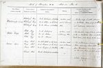
| < | List of Names as written on the Plan |
Various modes of Spelling the same Names |
Authority for those modes of Spelling |
Situation | Descriptive Remarks, or other General Observations which may be considered of Interest |
> |
|---|---|---|---|---|---|---|
| Whiteheugh Crag | Whiteheugh Crag | Mr A Rutherford of Emblehope | 40 chains south | A long ridge of rocks, situated | ||
| Whiteheugh Crag | Mr J. Robson of the Dodd | east of Dummy’s | on Embleton Moor, of great elevation | |||
| Whiteheugh Crag | Mr W. Thomson of Emblehope | Hole. | and conspicuous appearance. | |||
| Kittle Rigg | Kittle Rigg | Mr A. Rutherford | 37 chains south | An elevated ridge of land situated | ||
| Kittle Rigg | Mr J. Robson | of Dummy’s Hole. | partly on Embleton Moor and partly on | |||
| Kittle Rigg | Mr W. Thomson | Comb Moor; well known by the name. | ||||
| Fairys Kirk | Fairys Kirk | Mr Robt Scott of The Comb | 56 chains south | A subterraneous passage on Comb | ||
| Fairys Kirk | Mr R. Thomson of the Comb | east of Dummy’s | Moor extending about fifteen yards | |||
| Fairys Kirk | Mr J Thomson of Blackburn | Hole. | from the entrance and having a space | |||
| at the end about six feet square. | ||||||
| John Elliott Sapper Royal Engineers |
Abbreviations are underlined like this RE and the expansion may be seen by hovering the cursor over the abbreviation.
| An entry outlined like this has a note which may be seen by hovering the cursor over it. |
Transcribed by TH
Return to Thorneyburn index