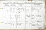
| < | List of Names as written on the Plan |
Various modes of Spelling the same Names |
Authority for those modes of Spelling |
Situation | Descriptive Remarks, or other General Observations which may be considered of Interest |
> |
|---|---|---|---|---|---|---|
| Green Rigg | Green Rigg | Mr. Allen, Whiteside | 19 Chains north | A long ridge of land extending from | ||
| Green Rigg | Mr. Robson. Sweethope | of Curtis | Watling Street to near Sweethope | |||
| Green Rigg | Mr. Herdman, Hawick | Crag. | Loughs it is about 1 1/2 Miles in | |||
| Green Rigg | Mr. Scott | length and across its summit | ||||
| runs a Township Road. | ||||||
| Cowstand Hill | Cowstand Hill | Mr. Allen | 42 Chains south | A hill of Slight elevation | ||
| Cowstand Hill | Mr. Herdman | east of Curtis | situated on the White House | |||
| Cowstand Hill | Mr. Scott | Crag. | farm. | |||
| Cowstand Hill | Mr. Robson | |||||
| Stell Rigg | Stell Rigg | Mr. Robson | 98 Chains east | A ridge of land on the Sweethope | ||
| Stell Rigg | Mr. Herdman | of Curtis Crag. | farm so Called from two small | |||
| Stell Rigg | Mr. Scott – | sheepfolds ie (locally Called | ||||
| "Stells") at its eastern end | ||||||
| John Stewart Lance Corporal Royal Engineers |
Abbreviations are underlined like this RE and the expansion may be seen by hovering the cursor over the abbreviation.
| An entry outlined like this has a note which may be seen by hovering the cursor over it. |
Transcribed by PT and PF
Return to Thockrington index