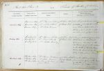
| < | List of Names as written on the Plan |
Various modes of Spelling the same Names |
Authority for those modes of Spelling |
Situation | Descriptive Remarks, or other General Observations which may be considered of Interest |
> |
|---|---|---|---|---|---|---|
| Carriers’ Way | Carriers Way | Mr Thomas Pickering | 21 chains West | An old pack horse road | ||
| Carriers Way | Mr Robert Bell | of Warlaw Pike. | extending from the Township | |||
| Carriers Way | Mr John Brown | road between Blanchland and | ||||
| Slaley in the south western | ||||||
| direction out of this Parish. | ||||||
| Embley Fell | Embley Fell | Mr Thomas Pickering | 22 chains West | A large district of unenclosed | ||
| Embley Fell | Mr Robert Smith | of Warlaw Pike. | moor land in Bulbeck | |||
| Embley Fell | Mr Matthew Cowing | Common bounded on the | ||||
| north and west by the enclosures | ||||||
| on the South by Embley Burn | ||||||
| and on the East by the Ph of | ||||||
| Slaley and Blanchland Moor. | ||||||
| Strothers Sike | Strothers Sike | Mr Thomas Pickering | 49 chains South | A small stream flowing | ||
| Strothers Sike | Mr John Brown | East of Warlaw | from a good spring at the head | |||
| Strothers Sike | A Plan of the Manor of | Pike | of Strothers in a N. Eastern | |||
| Blanchland | direction to Potters Burn. | |||||
| M. Costelloe Civil Assistant |
Abbreviations are underlined like this RE and the expansion may be seen by hovering the cursor over the abbreviation.
| An entry outlined like this has a note which may be seen by hovering the cursor over it. |
Transcribed by TH
Return to Shotley index