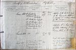
| < | List of Names as written on the Plan |
Various modes of Spelling the same Names |
Authority for those modes of Spelling |
Situation | Descriptive Remarks, or other General Observations which may be considered of Interest |
> |
|---|---|---|---|---|---|---|
| Tosson Hill | H. Ridell Esq | Sheet Traces | Applies to the highest point | |||
| Whitefield House | 53/1. 2.3 | of the "Simonside Hills" it | ||||
| Bickerton | is situated at western extremity | |||||
| A. Sneth Esq Bickerton | of the range | |||||
| Farm | ||||||
| Mr M. Thompson, Farmer | ||||||
| Ryehill, Near Great Tosson | ||||||
| C. Turnbull Esq Great | ||||||
| Tosson Farm | ||||||
| Simonside Hills | Do Do | 53/1/2.3 to 44/15/5 | Applies to a long range | |||
| of hills extending from | ||||||
| "Tosson Hill" to "The Beacon" | ||||||
| Burgh Hill | Mr Dawson, Farmer Spital | 44 | Burgh Hill applies to a sm | |||
| near Great Tosson | green knoll situated about | |||||
| C. Turnbull Esq Great Tosson | mile to the south west of | |||||
| Farm | "Great Tosson" | |||||
| M. Thompson, Farmer Ryehill | ||||||
| near Great Tosson | ||||||
Note: unsigned
Abbreviations are underlined like this RE and the expansion may be seen by hovering the cursor over the abbreviation.
| An entry outlined like this has a note which may be seen by hovering the cursor over it. |
Transcribed by PW
Return to Rothbury index