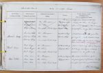
| < | List of Names as written on the Plan |
Various modes of Spelling the same Names |
Authority for those modes of Spelling |
Situation | Descriptive Remarks, or other General Observations which may be considered of Interest |
> |
|---|---|---|---|---|---|---|
| This name is [not] worth appearing on the Ordnance Plans J.D. | ||||||
| Hunters Loap | Hunters Loap | Mr Thompson | 22 1/2 Chains SE of | A well known spot with a great tree | ||
| Hunters Loap | Mr Oliver | Hunters Loap | growing over a rock & the place itself | |||
| Hunters Loap | Ramshope Parish Map | appears Naturally worn & sunk on the side of- | ||||
| -the Hill | ||||||
| West Edge | West Edge | Mr Thompson | 32 Chains S.W of | A name which only appears to be given | ||
| West Edge | Mr Oliver | Loap Cab House | to it being exactly in a westerly | |||
| West Edge | Ramshope Parish Map | position on the ground | ||||
| Tates Well | Tates Well | Mr Thompson | 80 Chains SW from | This well, is well known by the | ||
| Tates Well | Mr Oliver | Loap Cab House | Neighbouring people of the same locality | |||
| Tates Well | Ramshope Parish Map | as a very powerful stream gushes therefrom | ||||
| John Mulligan Civil Assistant | ||||||
Abbreviations are underlined like this RE and the expansion may be seen by hovering the cursor over the abbreviation.
| An entry outlined like this has a note which may be seen by hovering the cursor over it. |
Transcribed by CC and SMH
Return to Ramshope index