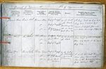
| < | List of Names as written on the Plan |
Various modes of Spelling the same Names |
Authority for those modes of Spelling |
Situation | Descriptive Remarks, or other General Observations which may be considered of Interest |
> |
|---|---|---|---|---|---|---|
| Prior’s Stone | Priors Stone | Map of Borough | On the South | A large rock 22 links by 23 | ||
| 182[7?] | of the Black | links broad & 12 links High. | ||||
| Priors Stone | Map of Township | Middings near | Covered at 5 1/2 feet flow only | |||
| 1848 | the low Water | and seldom bare unless at Spring Tides | ||||
| Priors Stone | Jos. Ogilvie | mark Spring Tides | ||||
| Salt Works | ||||||
| The Stones | The Stones | Jos. O |
On the South of | Some rough gravel and scattered | ||
| The Stones | James Wood | the Flats | Stones only visible at low Water | |||
| The Stones | Map of Township | Spring Tides | ||||
| 1828 | ||||||
| River Tyne | River Tyne | Map of Borough | On the South of | A wide and deep navigable | ||
| 1829 | the Ph & Tship | River from Tynemouth To | ||||
| River Tyne | Jos. Ogilvie | and forming the | Newcastle & Extending Several | |||
| N. Shields | Co Boundary | Miles westward | ||||
| River Tyne | James Wood | |||||
| Boatman | ||||||
Note: Unsigned. This 1857 Name Book has 6 columns; recommended forms are shown here but not provisional Names.Â
Abbreviations are underlined like this RE and the expansion may be seen by hovering the cursor over the abbreviation.
| An entry outlined like this has a note which may be seen by hovering the cursor over it. |
Transcribed by PT and PF
Return to North Shields index