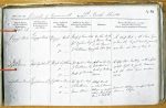
| < | List of Names as written on the Plan |
Various modes of Spelling the same Names |
Authority for those modes of Spelling |
Situation | Descriptive Remarks, or other General Observations which may be considered of Interest |
> |
|---|---|---|---|---|---|---|
| Peggy’s Hole | Peggy’s Hole | Map of Town 1848 | On the South | A deep Hole in the River Tyne | ||
| Peggy’s Hole | Jos. Ogilvie Esq | of Union Quay | where the largest vessels generally | |||
| Peggy’s Hole | J. Patterson Esq | in the Channel | anchor also Men of War &c. | |||
| of the River Tyne | ||||||
| High Lighthouse | High Lighthouse | Jos. Ogilvie Esq | |
A lofty stone building with a fixed | ||
| High Lighthouse | J. Patterson Esq | Bell Street and | white light to guide mariners | |||
| High Lighthouse | Map of Town 1848 | South of Dockwray | into the River Tyne erected in | |||
| Square | 1808 | |||||
| Lighthouse Bank | Lighthouse Bank | Jos. Ogilvie Esq | A steep Bank | Several cottages occupied by the | ||
| Lighthouse Bank | J. Patterson | on which several | labouring Classes | |||
| Lighthouse Bank | James Wood | Cottages are erected | ||||
| between High Light | ||||||
| House & Bell St. | ||||||
Note: Unsigned. This 1857 Name Book has 6 columns; recommended forms are shown here but not provisional Names.
Abbreviations are underlined like this RE and the expansion may be seen by hovering the cursor over the abbreviation.
| An entry outlined like this has a note which may be seen by hovering the cursor over it. |
Transcribed by CC and SMH
Return to North Shields index