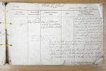
| < | List of Names as written on the Plan |
Various modes of Spelling the same Names |
Authority for those modes of Spelling |
Situation | Descriptive Remarks, or other General Observations which may be considered of Interest |
> |
|---|---|---|---|---|---|---|
| River Tweed | River Tweed | Map of Scotland | On Sheets | The popular and the really remotest | ||
| Map of Berwickshire | 3.10, 3.11, 3.14, 5.8, | source of the Tweed is a paltry | ||||
| Map of Northumberland | 5.12, 5.16, 6.1, 6.2, | fountain called Tweeds-well a | ||||
| 6.5, 6.9, 9.3, 9.3, 9.4, | little above the farm house of | |||||
| Not navigable above | 9.7 & | Tweedshaws and at the foot of | ||||
| Berwick Bridge. See | 9.11 | a hill named Tweed’s Cross, on | ||||
| remark 11 on plan 6/2 | the south-western boundary of | |||||
| Tweedsmuir in Peebleshire. | ||||||
| From its remote source to the sea at Berwick upon Tweed | ||||||
| it performs irrespectively of windings, a run of about 100 miles & | ||||||
| drains 1870 square miles. | ||||||
| For a distance of 13 miles & 50 chains, the Tweed separates | ||||||
| Norham parish in Northumberland from the Parishes | ||||||
| of Coldstream, Ladykirk & Hutton in Berwickshire. | ||||||
| William Beatty Civil Assistant | ||||||
Note: Signature in header
Abbreviations are underlined like this RE and the expansion may be seen by hovering the cursor over the abbreviation.
| An entry outlined like this has a note which may be seen by hovering the cursor over it. |
Transcribed by TH
Return to Norham index