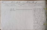
| < | List of Names as written on the Plan |
Various modes of Spelling the same Names |
Authority for those modes of Spelling |
Situation | Descriptive Remarks, or other General Observations which may be considered of Interest |
> |
|---|---|---|---|---|---|---|
| [#] | Maiden Way | Hill about 150 yards except at the top | ||||
| (ROMAN ROAD) | of the first Steep Brow where the | |||||
| present road turns abruptly to the | ||||||
| right and turns again Close by on | ||||||
| the Side of the is a House Called the | ||||||
| Maiden Way House, Said to have | ||||||
| been built on the old Way, but | ||||||
| probably on the West if it." | ||||||
| From the last hill top | ||||||
| probably through the pasture on the | ||||||
| right, but in the present devious | ||||||
| Steep and awkward road, but in a | ||||||
| fine slope towards the Cow Mill in | ||||||
| the Hollow, Crossing <u>Killa Burn</u> | ||||||
| and the Black Burn, on the right | ||||||
| of Mill, and along the present road | ||||||
| up the Steep bank on the Side." | ||||||
| "Along the present road for | ||||||
| more than a mile in a Straight line | ||||||
| to the Alston turnpike road leading to | ||||||
| Milton which it Cuts at right angles" | ||||||
| "It Crosses the Burn after | ||||||
| making a Slight turn to the right | ||||||
| to avoid the Steep descent and ascent | ||||||
| passes the Public House close | ||||||
| by the the turnpike road ten or | ||||||
| twelve yards on the West." | ||||||
| The old road from Alston to | ||||||
| the Coal pits here, used up to the year | ||||||
| 1824, now grassed over, is upon the | ||||||
| Maiden Way to within half a mile of | ||||||
| Burnstones." | ||||||
| Up a Steepish hill on | ||||||
| the unenclosed waste part of Tindale | ||||||
| Fell for a mile directly South, SEE PAGE 5 | ||||||
| then | ||||||
Note: Not signed but written in the hand of George Davison $Junr$
Abbreviations are underlined like this RE and the expansion may be seen by hovering the cursor over the abbreviation.
| An entry outlined like this has a note which may be seen by hovering the cursor over it. |
Transcribed by PT
Return to Lambley index