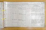
| < | List of Names as written on the Plan |
Various modes of Spelling the same Names |
Authority for those modes of Spelling |
Situation | Descriptive Remarks, or other General Observations which may be considered of Interest |
> |
|---|---|---|---|---|---|---|
| Black Bog | Black Bog | Mr Thompson Kirknewton | on Sheet | A portion of the Hill thus named at the | ||
| Adam Black | 18. 4 & | junction of the boundary between West Newton | ||||
| Estate Map of Elsdon Burn | 18. 8 | and the Elsdon Burn properties, about | ||||
| 1/2 a mile north from the shepherds house | ||||||
| at Elsdon Burn, it has no feature to | ||||||
| distinguish it, the name being merely a | ||||||
| local one to define the spot | ||||||
| Crowden Sike | Crowden Sike | Mr Thompson | on Sheet | A small stream near the house at | ||
| Adam Black | 18. 8 | Elsdon Burn, rising in a valley on the | ||||
| Estate Map of Elsdon Burn | side of the hill, and joining the Elsdon | |||||
| Burn near the above house | ||||||
| Countrup Sike | Countrup Sike | Mr. Thompson | on Sheet | A small stream at the northern side | ||
| Mr. Calder Yetholm Mains | 18. 2 | of the parish, it rises on the north side | ||||
| Dr Turner Yetholm | 18. 3 & | of Coldsmouth, and skirts the boundary | ||||
| Countrup Sike | Decreit of the Lords of | 18. 7 | wall between the two Kingdoms and | |||
| Council & Sessions | finally joins the Halter Burn on the | |||||
| held at Edinburgh | farm of Yetholm Mains. | |||||
| 25th February 1713 | ||||||
| Countrup | Yetholm Name List | |||||
| William Boyd Civil Assistant |
Note: Signature in header, 'Described by'
Abbreviations are underlined like this RE and the expansion may be seen by hovering the cursor over the abbreviation.
| An entry outlined like this has a note which may be seen by hovering the cursor over it. |
Transcribed by ARJC
Return to Kirknewton index