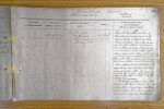
| < | List of Names as written on the Plan |
Various modes of Spelling the same Names |
Authority for those modes of Spelling |
Situation | Descriptive Remarks, or other General Observations which may be considered of Interest |
> |
|---|---|---|---|---|---|---|
| The Cheviot | The Cheviot | Mr John Oliver | on Sheet | This is the princip |
||
| or Cheviot | Mr Wm Henderson | 24. C | the extensive range, known as the | |||
| Estate Maps (3) | Cheviot Hills, on the borders between | |||||
| Directory &c. &c. | Enland & Scotland. It is a lofty mountain | |||||
| over 2600 ft in altitude, its sides are | ||||||
| covered with rough rocky pasturage, and | ||||||
| it is covered, as it were, with a soft | ||||||
| spongy moss which retains much water, | ||||||
| and which, in several parts is laid open | ||||||
| by the weather, thereby exposing a layer of | ||||||
| Peat Moss – between it and the rock. | ||||||
| A very extensive view is obtained from the | ||||||
| top of Cheviot into Cumberland, Roxburgh, | ||||||
| & Berwick Counties, with a long range of | ||||||
| Coast to the E. where Ships can be | ||||||
| seen in fine clear weather with the | ||||||
| naked eye. | ||||||
| The following streams have their | ||||||
| sources on the top of Cheviot Viz: | ||||||
| College Burn, Bazzle Burn, Bellyside | ||||||
| Burn – and on the E brow rises Lambden | ||||||
| Burn, and S side rises Harthope Burn. | ||||||
| Robt Young Corporal Royal Engineers |
Note: Signature in header, 'Described by'
Abbreviations are underlined like this RE and the expansion may be seen by hovering the cursor over the abbreviation.
| An entry outlined like this has a note which may be seen by hovering the cursor over it. |
Transcribed by ARJC
Return to Kirknewton index