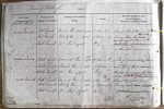
| < | List of Names as written on the Plan |
Various modes of Spelling the same Names |
Authority for those modes of Spelling |
Situation | Descriptive Remarks, or other General Observations which may be considered of Interest |
> |
|---|---|---|---|---|---|---|
| North Currock | North Currock | Manorial Plan dated "1774" | 35 Chains N.W. | A small pile of stones on the | ||
| North Currock | Property Plan dated "1825" | of Watchcurrock | boundary between the |
|||
| North Currock | Mr Paul (agent) | Spring | Kirkhaugh & Knaresdale & situated | |||
| on Thornhope Carrs | ||||||
| Middle Currock | Middle Currock | Manorial Plan date "1774" | 19 Chains N.E. | A large particulalrly promi- | ||
| Middle Currock | Property Plan date "1825" | of Watchcurrock | nent pile of stones, situated on | |||
| Middle Currock | Mr Paul (Agent) | Spring | Thornhope Carrs and on the Bdy | |||
| Parishes of Kirkhaugh & Knaresdale | ||||||
| between the ^ |
||||||
| South Currock | South Currock | Manorial Plan date 1774 | 17 Chains N.W. | A small pile of stones forming a | ||
| South Currock | Property Plan date 1825 | of Watchcurrock | boundary mark |
|||
| South Currock | Mr Paul Agent | Spring | ||||
| Thomas Jordan Lance Corporal Royal Engineers |
Abbreviations are underlined like this RE and the expansion may be seen by hovering the cursor over the abbreviation.
| An entry outlined like this has a note which may be seen by hovering the cursor over it. |
Transcribed by EDA
Return to Kirkhaugh index