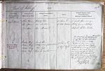
| < | List of Names as written on the Plan |
Various modes of Spelling the same Names |
Authority for those modes of Spelling |
Situation | Descriptive Remarks, or other General Observations which may be considered of Interest |
> |
|---|---|---|---|---|---|---|
| Lort Burn | Lort Burn | Property Plan | 45 Chains E. | A small stream rising in | ||
| Lort Burn | Mr Jackson | of Little Heaplaw | Whitley Common & Emptying | |||
| Lort Burn | Mr Stoddart | itself into the River South Tyne | ||||
| Maiden Way | Maiden Way | Bruce’s Plan | 3 Chains E. | An ancient Roman Road, which | ||
| ROMAN ROAD | Maiden Way | Kitchen’s map of Northumberland | of High Dyke | is only partially traceable | ||
| (Site of) | Maiden Way | Dr Gill | in this Parish, through which | |||
| Maiden Way | Revd H. Morton | it runs nearly North and South. | ||||
| The farmers from whom I have | ||||||
| received information have ploughed | ||||||
| up the stones in many places. | ||||||
| It crosses Knaresdale Burn and | ||||||
| runs nearly straight, to about 60 | ||||||
| yards E. of Whitley Castle, thence to | ||||||
| where the Turnpike crosses Thornhope | ||||||
| Burn in the adjoining Parish Alston, Co of Cumberland. | ||||||
| part of it is still used as a Cart way across the | ||||||
| moor | ||||||
| Thomas Jordan Lance Corporal Royal Engineers |
Abbreviations are underlined like this RE and the expansion may be seen by hovering the cursor over the abbreviation.
| An entry outlined like this has a note which may be seen by hovering the cursor over it. |
Transcribed by EDA
Return to Kirkhaugh index