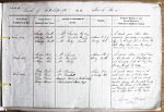
| < | List of Names as written on the Plan |
Various modes of Spelling the same Names |
Authority for those modes of Spelling |
Situation | Descriptive Remarks, or other General Observations which may be considered of Interest |
> |
|---|---|---|---|---|---|---|
| Sonsy Nook | Sonsy Nook | Mr Davison Ray Tongue | 8 Chains N E of | A small green Dell or Hollow | ||
| Sonsy Nook | Mr Turnbull Ferneyrigg | Midge Hole | consisting principally of rough pasture | |||
| Sonsy Nook | Mr Betty Cornhills | lying in the angle formed between Ray | ||||
| Fell Risey Burn and Ray Tongue | ||||||
| "Sonsy thriving" Brockett’s Glossary | ||||||
| Midge Hole | Midge Hole | Mr Davison | 8 Chains S.W. of | A small hollow of Rough Pasture | ||
| Midge Hole | Mr Turnbull | Sonsy Nook | in the parishes of Kirkwhelpington | |||
| Midge Hole | Mr Betty | and Corsenside with the Risey Burn | ||||
| flowing through its centre | ||||||
| "Midge Small Gnat" Brocketts Glossary | ||||||
| Risey Burn | Risey Burn | Mr Davison | 1 Chain West | A small stream rising on the | ||
| Risey Burn | Mr Turnbull | of Midge Hole | north-west side of Wanney’s Crags | |||
| Risey Burn | Hodgson’s History of Northumberland | and flows in a north and westerly | ||||
| direction forming the principal boundary | ||||||
| between the Parishes of Kirkwhelpington | ||||||
| and Corsenside, until it empties itself | ||||||
| into the Lisle’s Burn at Ray Tongue | ||||||
| Alfred Brittain Sapper Royal Engineers |
Abbreviations are underlined like this RE and the expansion may be seen by hovering the cursor over the abbreviation.
| An entry outlined like this has a note which may be seen by hovering the cursor over it. |
Transcribed by EDA
Return to Kirkwhelpington index