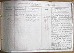
| < | List of Names as written on the Plan |
Various modes of Spelling the same Names |
Authority for those modes of Spelling |
Situation | Descriptive Remarks, or other General Observations which may be considered of Interest |
> |
|---|---|---|---|---|---|---|
| Cheviot Hills | Cheviot Hills | Fullerton’s Gazetteer | On Sheets | A range of Mountains separating | ||
| Map of Scotland | 23 D | throughout a considerable portion of | ||||
| Map of England | 24 C | its extent, the Kingdoms of England | ||||
| 28 A | and Scotland | |||||
| 28 B | Some regard this chain as commencing | |||||
| 28 C | at Loch Ryan on the west, & extending | |||||
| 28 D | with occasional interruptions, to | |||||
| 29 A | the head of Northumberland | |||||
| 29 C | Bowmont, but the Cheviots, | |||||
| 29 D & | Commonly so called, lie in the | |||||
| 36 A | borders of Northumberland & | |||||
| Roxburgh, and may be regarded | ||||||
| as commencing in the East with | ||||||
| "Cheviot Hill" & its Eastern & Southern | ||||||
| slopes, in lat. 55 degree, 29 minutes, 0 seconds- 19 miles | ||||||
| from Sunderland point. | ||||||
| This hill the highest in the Range | ||||||
| W Beatty |
Abbreviations are underlined like this RE and the expansion may be seen by hovering the cursor over the abbreviation.
| An entry outlined like this has a note which may be seen by hovering the cursor over it. |
Transcribed by DP
Return to Kidland index