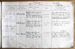
| < | List of Names as written on the Plan |
Various modes of Spelling the same Names |
Authority for those modes of Spelling |
Situation | Descriptive Remarks, or other General Observations which may be considered of Interest |
> |
|---|---|---|---|---|---|---|
| Standrop Rig | Stan |
Wm Atkinson Esqr. Rosedon Proprietor | on Sheet | This is a Spur or lateral shoot from the | ||
| Cr Atkinson Esqr. Rosedon Farmer | 24. 15 | South side of Hedgehope Hill, which Coups | ||||
| Estate Map in proprietor’s possession | in a curve down between |
|||||
| dated 1837. by J. Cook Civil Engr | towards Linhope, it is a wild desolate place – | |||||
| Little Standrop | Little Stan |
Wm Atkinson Esqr. Proprietor | On Sheet | A small conical cluster of rocks | ||
| Cr Atkinson Esqr. Farmer | 24. 15 | so called near the North part | ||||
| Estate Map in Proprietor’s possession | of Stan |
|||||
| dated 1837, by J. Cook CE | ||||||
| Great Standrop | Great Stan |
Wm Atkinson Esqr. Proprietor | On Sheet | A large mass of high pointed rocks so called, | ||
| Cr Atkinson Esqr. Farmer | 24. 15 | near the middle part of Stan |
||||
| Estate Map in Proprietor’s possession | drop Rig. Origin | |||||
| dated 1837, by J. Cook CE | of this name unknown. | |||||
| Robt Young Corporal Royal Engineers |
Note: Signature in header, 'Described by'
Abbreviations are underlined like this RE and the expansion may be seen by hovering the cursor over the abbreviation.
| An entry outlined like this has a note which may be seen by hovering the cursor over it. |
Transcribed by ARJC
Return to Ingram index