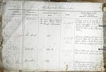
| < | List of Names as written on the Plan |
Various modes of Spelling the same Names |
Authority for those modes of Spelling |
Situation | Descriptive Remarks, or other General Observations which may be considered of Interest |
> |
|---|---|---|---|---|---|---|
| Castle Point | Castle Point | Mr Boak, Officer of Coastguard | on sheet | A narrow neck of low gravelly land | ||
| Castle Point | Mr Wilson, Harbour Master | 12.7 | at high water mark with shingle and | |||
| Castle Point | Mr Robert Stamp, Schoolmaster | boulder beach off it to low water mark | ||||
| east of the Castle, and a prominent | ||||||
| mark to vessels entering Holy Island | ||||||
| Harbour. | ||||||
| Hole Mouth | Hole Mouth | Mr Boak | on sheet | A narrow anchorage for vessels unable | ||
| Hole Mouth | Mr Wilson | 12.7 | to round Ridge End on entrance to the | |||
| Hole Mouth | Mr Robert Stamp | harbour, between Castle Point and Ridge | ||||
| End, with water depth of 7 feet at L.W. | ||||||
| Cockle Stone | Cockle Stone | Mr Boak | on sheet | A small black rock about 60 ft below | ||
| Cockle Stone | Mr Wilson | 12.7 | high water mark south west of the Castle | |||
| Cockle Stone | Mr Robert Stamp | |||||
| Riding Stone | Riding Stone | Mr Boak | on sheet | A black rock amidst boulders about 300 | ||
| Riding Stone | Mr Wilson | 12.7 | feet below high water mark a short way | |||
| Riding Stone | Mr Robert Stamp | west of ‘Cockle Stone’, the top of which | ||||
| when above water serving as an in- | ||||||
| dicator of the fordableness of the sands to Beal | ||||||
Note: Unsigned
Abbreviations are underlined like this RE and the expansion may be seen by hovering the cursor over the abbreviation.
| An entry outlined like this has a note which may be seen by hovering the cursor over it. |
Transcribed by CC and SMH
Return to Holy Island index