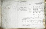
| < | List of Names as written on the Plan |
Various modes of Spelling the same Names |
Authority for those modes of Spelling |
Situation | Descriptive Remarks, or other General Observations which may be considered of Interest |
> |
|---|---|---|---|---|---|---|
| River Tweed | River Tweed | Map of Northumberland | on sheets | The popular and the really remotest | ||
| River Tweed | Map of Roxburghshire | 3.8 | source of the Tweed, is a paltry | |||
| River Tweed | Map of Berwickshire | 3.11 | Fountain called Tweeds well a | |||
| 3.12 | little above the farnhouse of | |||||
| 3.16 | Tweedshaws, and at the foot | |||||
| 4.5 & | of a hill named Tweeds Cross on | |||||
| 4.9 | the south western boundary | |||||
| of the parish of Tweedsmuir | ||||||
| Peebleshire. The well is 1500 feet | ||||||
| above the level of the sea | ||||||
| From its remotest source, to the sea at Berwick upon Tweed, it performs | ||||||
| irrespectively of windings, a run of about 100 miles and drains 1870 | ||||||
| square miles | ||||||
| The Tweed is not navigable above Berwick Bridge by vessels | ||||||
| longer than a fishing coble. The ordinary spring tides flow as | ||||||
| high as the west end of St Thomas’s Island, and about twice | ||||||
| a year, the springs nearest the equinoxes flow as high as | ||||||
| Norham Castle. | ||||||
Note: Unsigned
Abbreviations are underlined like this RE and the expansion may be seen by hovering the cursor over the abbreviation.
| An entry outlined like this has a note which may be seen by hovering the cursor over it. |
Transcribed by CC and SMH
Return to Holy Island index