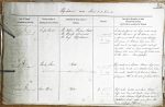
| < | List of Names as written on the Plan |
Various modes of Spelling the same Names |
Authority for those modes of Spelling |
Situation | Descriptive Remarks, or other General Observations which may be considered of Interest |
> |
|---|---|---|---|---|---|---|
| Snipe Point | Snipe Point | Mr Wilson, Harbourmaster | on sheet | A small point at high water mark | ||
| Snipe Point | Mr Stamp, Schoolmaster | 8.14 | at the N.E. corner of the Island and | |||
| Snipe Point | Mr Grey, Holy Island | a prominent mark seaward – stretching | ||||
| out from it between high and low | ||||||
| water mark are ridges and flat rocks of | ||||||
| limestone which are being continually quarried | ||||||
| between tides and led away by a tram road | ||||||
| to the kilns. Crown property.- | ||||||
| Buck Skerrs | Buck Skiers | Mr Wilson | on sheet | Flat rocks and boulders between high and | ||
| Buck Skiers | Mr Stamp | 8.14 | low water marks, and detached rocks below | |||
| Buck Skiers | Mr Grey | low water, resorted to for crab and lobster | ||||
| Skerrs | Jamieson’s Scottish Dictionary | fishing – on the north side of Snipe Point. | ||||
| Caves Haven | Caves Haven | Mr Wilson | on sheet | Flat rocks, boulders and sand between | ||
| Caves Haven | Mr Stamp | 8.14 | high and low water marks, and below | |||
| Caves Haven | Mr Grey | low water, between Snipe Pt rocks and | ||||
| Castlehead Rock’s, taking name from the | ||||||
| Caves north of "Nessend". | ||||||
Note: Unsigned
Abbreviations are underlined like this RE and the expansion may be seen by hovering the cursor over the abbreviation.
| An entry outlined like this has a note which may be seen by hovering the cursor over it. |
Transcribed by CC and SMH
Return to Holy Island index