| < | List of Names as written on the Plan |
Various modes of Spelling the same Names |
Authority for those modes of Spelling |
Situation | Descriptive Remarks, or other General Observations which may be considered of Interest |
> |
|---|---|---|---|---|---|---|
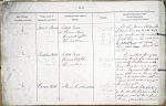
| Beal Sands | Beal Sands | Estate Map | on sheets | All the sand in the township | ||
| Beal Sands | Mr Thomas Main | 11.4 | of Beal, bounded by the High | |||
| Beal Sands | Mr David Wright | 11.8 | water mark on the west, by the | |||
| Beal Sands | Mr John Mathison | 12.1 & | South Low, on the east, and by | |||
| 12.5 | Black Burn on the South, | |||||
| the is some |
||||||
| the shore. | ||||||
| Suddon Well | Suddon Well | Estate Map | on sheet | An excellent spring well | ||
| Suddon Well | Mr David Wright | 11.4 | south of Beal, farm house, |
|||
| Suddon Well | Mr Thomas Main | it is neatly built round, with | ||||
| hewn stone, and is a very old | ||||||
| well. I could not obtain the | ||||||
| origin of this name, but it is sup- | ||||||
| posed to be a corruption of the word | ||||||
| "Soda" as the water is very good | ||||||
| for infusing Tea. | ||||||
| Carrow Hill | Carrow Hill | Estate Map | on sheet | A small hill feature | ||
| Carrow Hill | Mr David Wright | 11.4 | in an arable field, a short | |||
| Carrow Hill | Mr Thomas Main | distance east of Beal farm | ||||
| house, (derivation unknown) | ||||||
Note: No heading; unsigned
Abbreviations are underlined like this RE and the expansion may be seen by hovering the cursor over the abbreviation.
| An entry outlined like this has a note which may be seen by hovering the cursor over it. |
Transcribed by CC and SMH
Return to Holy Island index