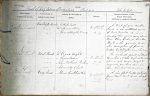
| < | List of Names as written on the Plan |
Various modes of Spelling the same Names |
Authority for those modes of Spelling |
Situation | Descriptive Remarks, or other General Observations which may be considered of Interest |
> |
|---|---|---|---|---|---|---|
| Cockdyke Quarter | Cockdyke Quarter | Estate Map | on Sheet | A tract of good arable | ||
| Cockdyke Quarter | Mr Thomas Main | 11.4 | land in the northeast corner | |||
| Cockdyke Quarter | Mr David Wright, Tenant | of Beal Township, the fences | ||||
| dividing this ground were at one | ||||||
| time thorn bushes (or branches) | ||||||
| stuck in the ground, and | ||||||
| this description of fence is | ||||||
| called "Cock Dyke", hence the name | ||||||
| Beal Point | Beal Point | Mr David Wright | on Sheet | The northeast point of Beal | ||
| Beal Point | Mr Thomas Main | 11.4 | township, at |
|||
| Beal Point | Mr John Mathison, Fenham | It is a well known point to | ||||
| Beal Point | Admiralty Chart | mariners, and laid down on | ||||
| their charts of the coast. | ||||||
| Crag End | Crag End | Mr David Wright | on sheet | A few flat rocks, extending | ||
| Crag End | Mr Thomas Main | 11.4 | from "Beal Point" to the South | |||
| Crag End | Mr John Mathison, Fenham | Low | ||||
| Crag End | Admiralty Chart | |||||
| John McCabe |
Note: Signature in header
Abbreviations are underlined like this RE and the expansion may be seen by hovering the cursor over the abbreviation.
| An entry outlined like this has a note which may be seen by hovering the cursor over it. |
Transcribed by CC and SMH
Return to Holy Island index