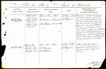
| < | List of Names as written on the Plan |
Various modes of Spelling the same Names |
Authority for those modes of Spelling |
Situation | Descriptive Remarks, or other General Observations which may be considered of Interest |
> |
|---|---|---|---|---|---|---|
| Black Dike | Black Dike | Bruce’s Roman Wall | 22 Chains South | A modern drystone wall forming | ||
| (Site of) | (Site of) | of Stanegate | part of the eastern boundary of this | |||
| Black Dike | Mr Woodman Thorngrafton | parish formerly the site of an earthen | ||||
| (Site of) | mound and ditch which is supposed to | |||||
| Black Dike | Mr Makepeace Crindle Dikes | have formed the boundary between the | ||||
| (Site of) | ||||||
| and Cumberland the latter of which | ||||||
| during the period of Saxon Heptarchy | ||||||
| formed part of the Scottish Kingdom | ||||||
| slight remains of this Antiquity still | ||||||
| exist on the south side of Muckle Moss | ||||||
| See trace where the remains are etched | ||||||
| Muckle Moss | Muckle Moss | Bruce’s Roman Wall | 8 Chains South | A large flat Moss forming a | ||
| Muckle Moss | Mr Woodman | of Stanegate | remarkable looking feature it is | |||
| Muckle Moss | Mr Makepeace | very wet in places & dangerous | ||||
| to cross. | ||||||
| John Stewart 2nd Corporal Royal Engineers |
Abbreviations are underlined like this RE and the expansion may be seen by hovering the cursor over the abbreviation.
| An entry outlined like this has a note which may be seen by hovering the cursor over it. |
Transcribed by PW and CTW
Return to Haltwhistle 374 index