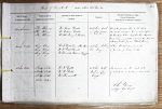
| < | List of Names as written on the Plan |
Various modes of Spelling the same Names |
Authority for those modes of Spelling |
Situation | Descriptive Remarks, or other General Observations which may be considered of Interest |
> |
|---|---|---|---|---|---|---|
| The Knares | The Knares | Mr. Walter Dodd | 14 Chains East | One of the principal Hills in this Parish | ||
| The Knares | Mr. William Dodd | of Long Crags. | the water shedding line of which forms | |||
| The Knares | Mr. Adam Murray. F. Whitehill. | the boundary between Paddaburn Moor & Hopehouse | ||||
| Moor Commencing at the west end of Barren Crags and | ||||||
| extending North as far as "Black Knowe" | ||||||
| Long Crags | Long Crags | Mr. W. Dodd. Farmer. Hope House | 15 Chains South of | A brow thickly covered with | ||
| Long Crags | Mr. Wm Dodd. Churnsike | Ox Crag. | a number of loose rocks. | |||
| Long Crags | Mr. Thomas Scott. Watchman. Churnsike | |||||
| Lodge | ||||||
| Slaty Pike | Slat |
Mr. W. Dodd | 15 Chains North | An eminence on the west side | ||
| Slat |
Mr. Wm Dodd | West of Long | of which are a number of loose rocks. | |||
| Slat |
Mr. Thomas Scott | Crags. | ||||
| Slaty Pike | ||||||
| John Davison Sapper Royal Engrs |
Abbreviations are underlined like this RE and the expansion may be seen by hovering the cursor over the abbreviation.
| An entry outlined like this has a note which may be seen by hovering the cursor over it. |
Transcribed by ARJC
Return to Greystead index