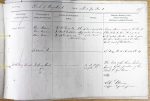
| < | List of Names as written on the Plan |
Various modes of Spelling the same Names |
Authority for those modes of Spelling |
Situation | Descriptive Remarks, or other General Observations which may be considered of Interest |
> |
|---|---|---|---|---|---|---|
| Gair Burn | Gair Burn | Mr Wm Dodd. Farmer. Churnsike | Forms part of the | A good stream, rising in the County | ||
| Gair Burn | Mr Walter Dodd. Farmer. Hope House | western boundary | of Cumberland, then flowing in an | |||
| Gair Burn | Mr H. Goodfellow. Farmer. | of this Parish. | South easterly direction until it joins | |||
| (Redsike Cumberland) | the River Irthing about 68 Chains | |||||
| north west of Paddaburn. | ||||||
| Paddaburn Moor | See Name Book Sheet 66 Plan 14 | |||||
| Irthing Head | Irthing Head | On the Western | The head of the River Irthing | |||
| Irthing Head | end of the Ph | formed by the junction of Tarn Beck | ||||
| Irthing Head | Beck & Gair Burn. | |||||
| John Davison Sapper Royal Engineers |
Abbreviations are underlined like this RE and the expansion may be seen by hovering the cursor over the abbreviation.
| An entry outlined like this has a note which may be seen by hovering the cursor over it. |
Transcribed by ARJC
Return to Greystead index