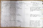
| < | List of Names as written on the Plan |
Various modes of Spelling the same Names |
Authority for those modes of Spelling |
Situation | Descriptive Remarks, or other General Observations which may be considered of Interest |
> |
|---|---|---|---|---|---|---|
| Dovehole Crag | Dovehole Crag | Mr Thomas | On Sheet | A rocky part of Broom Ridge | ||
| Mr Ormiston | 14.4 | near the west end of the Ridge | ||||
| Estate Map | the name is called by the | |||||
| peasantry The Devils Crag – which | ||||||
| is most probably a corruption of | ||||||
| Dove Hole | ||||||
| Dovehole Hill | Dovehole Hill | Mr Thomas | On Sheet | A part near the west end | ||
| Mr Ormiston | 14.4 | of Broom Ridge having a | ||||
| Estate Map | distinct feature. Known by this | |||||
| name on the estate. | ||||||
| Broomridge Dean | Broomridge Dean | Mr Thomas | On Sheet | A deep ravine on the south | ||
| Mr Ormiston | 14.4 | side of Broom Ridge, through | ||||
| Estate Map | which runs a small stream | |||||
| that divides the Parish from | ||||||
| Wooler. this name only refers | ||||||
| to that side of the glen belonging | ||||||
| to Ford, it being called Howden- | ||||||
| bank Dean on the Wooler side from | ||||||
| the name of the property | ||||||
| William Boyd Civil Assistant |
Note: Signature in header ('Described by')
Abbreviations are underlined like this RE and the expansion may be seen by hovering the cursor over the abbreviation.
| An entry outlined like this has a note which may be seen by hovering the cursor over it. |
Transcribed by LF
Return to Ford index