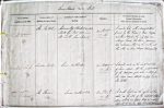
| < | List of Names as written on the Plan |
Various modes of Spelling the same Names |
Authority for those modes of Spelling |
Situation | Descriptive Remarks, or other General Observations which may be considered of Interest |
> |
|---|---|---|---|---|---|---|
| The Kettle | The Kettle | Admiralty Charts 1789-1858 | on Sheet | A circular hole with a sandy bottom | ||
| The Kettle | North Sea Pilot 1859 | 17.A | formed by the ‘Knoxes or Noxes’; Brigses, | |||
| The Kettle | Mr Troth, Farne Island | and Farne Island, the only safe an- | ||||
| -chorage beside the Farne, possessing | ||||||
| two entrances – that on the north, and | ||||||
| the other on S.E. – through Wideopen Gut | ||||||
| London Rock | London Rock | Admiralty Charts 1789-1858 | on Sheet | A small rock on the south east side | ||
| London Rock | North Sea Pilot 1859 | 17.A | of Farne island at the west entrance | |||
| London Rock | Mr Troth, Farne Island | of the Wideopen gut where a ship of | ||||
| the same name struck in trying to gain | ||||||
| The Kettle | ||||||
| The Thorn | The Thorn | Admiralty Charts 1789-1858 | on Sheet | A small bight in the rocks at low | ||
| North Sea Pilot 1859 | 17.A | water, on the S.E. of the eastward Wide | ||||
| Mr Troth, Farne Island | -open, which in flood tides is most | |||||
| difficult to round, – and hence the name. | ||||||
Note: Unsigned
Abbreviations are underlined like this RE and the expansion may be seen by hovering the cursor over the abbreviation.
| An entry outlined like this has a note which may be seen by hovering the cursor over it. |
Transcribed by SMH and CC
Return to Farne index