| < | List of Names as written on the Plan |
Various modes of Spelling the same Names |
Authority for those modes of Spelling |
Situation | Descriptive Remarks, or other General Observations which may be considered of Interest |
> |
|---|---|---|---|---|---|---|
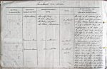
| Staples Island | Staples Island | Admiralty Chart | on Sheet | This islet is the westernmost of the | ||
| Staples Island | Mr Tate; Alnwick | 12.d.D | outer cluster, and often gives name | |||
| Staples Island | Mr Darling; Longstone | to those extending easterly half a mile: | ||||
| Staples Island | Mr Patterson; Monkshouse | it is of a triangular shape, with | ||||
| scanty vegetation, as the surface is for | ||||||
| the most part rocky, and having a | ||||||
| bold cliff on its southern side: there | ||||||
| -house tower on its highest part | ||||||
| Brownsman Haven | Brownsman Haven | Admiralty Chart | on Sheet | A narrow passage or Channel | ||
| Brownsman Haven | Mr Tate; Alnwick | 12.d.D | between Brownsman Island, | |||
| Brownsman Haven | Mr Darling; Longstone | Roddam & Green, & South Wanses – | ||||
| Brownsman Haven | Mr Patterson; Monkshouse | |||||
| Brownsman | Brownsman Island | Admiralty Chart | on Sheet | Brownsman island almost joins Staples | ||
| Island | Brownsman Island | Mr Tate; Alnwick | 12.d.D | island and at low water the passage | ||
| Brownsman Island | Mr Darling; Longstone | between these is dry. There is a bold | ||||
| Brownsman Island | Mr Patterson; Monkshouse | cliff, about 40 feet high, on South and | ||||
| west sides, and there is a deserted | ||||||
| tower, and the remains of another one | ||||||
| both formerly being lighthouses, and a | ||||||
| house used in summer as the residence | ||||||
| of the person, who watches the birds | ||||||
Note: Unsigned
Abbreviations are underlined like this RE and the expansion may be seen by hovering the cursor over the abbreviation.
| An entry outlined like this has a note which may be seen by hovering the cursor over it. |
Transcribed by SMH and CC
Return to Farne index