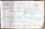
| < | List of Names as written on the Plan |
Various modes of Spelling the same Names |
Authority for those modes of Spelling |
Situation | Descriptive Remarks, or other General Observations which may be considered of Interest |
> |
|---|---|---|---|---|---|---|
| Hogswood Moor | Hogswood Moor | Mr. Nichol | Extending from "Rig |
An unenclosed District |
||
| Hogswood Moor | Mr. Davidson | Burn to the Parish boundary | ||||
| Hogswood Moor | Mr. Robson | of Thorneyburn | Farm Comprising |
|||
| Wolf K |
A County Map (Date 1828) | Wolf K |
Rocks &c. Bounded on the east by the | |||
| been the ancient name of | Parish boundary of Thorneyburn, & on the west | |||||
| this moor but it is now | by Rig |
|||||
| obsolete | ||||||
| Long Sike | Long Sike | Mr. Nichol | 19 Chains South | A Small Stream rising on Hogswood | ||
| Long Sike | Mr. Davidson | West of Sandys Sike | Moor & flowing in a north westerly direction | |||
| Long Sike | Mr. Robson | until it Joins Rig |
||||
| East K |
See name Book Sheet 49 Plan 4 | |||||
| Rig |
See name Book Sheet 49 Plan 4 | |||||
| Little Blackcleugh | See name Book Sheet 49 Plan 7 | |||||
| Black Cleugh | See name Book Sheet 49 Plan 7 | |||||
| James Doherty Lce Corpl RE |
Abbreviations are underlined like this RE and the expansion may be seen by hovering the cursor over the abbreviation.
| An entry outlined like this has a note which may be seen by hovering the cursor over it. |
Transcribed by BFR and BER
Return to Falstone 367 index