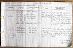
| < | List of Names as written on the Plan |
Various modes of Spelling the same Names |
Authority for those modes of Spelling |
Situation | Descriptive Remarks, or other General Observations which may be considered of Interest |
> |
|---|---|---|---|---|---|---|
| Peel Fell | Pearl Fell | White’s Directory | Situated at the North | A prominent hill. Situated on | ||
| Pearl Fell} | Western extremity of | the Boundary between England and | ||||
| Pearl Fell} | Mr. Nichol | West Keilder Moor | Scotland. This hill is Commonly | |||
| Pearl Fell} | Mr. Davidson | Called Peel Fell. But local tradition | ||||
| Peel Fell } | Mr. Robson | gives it as a place where Pearl Stones | ||||
| Peel Fell } | were found in former times by which the name | |||||
| Peel Fell } | Pearl Fell is derived | |||||
| Pearl Fell | A County Map Published AD 1828 | |||||
| Master Grain |
Master Grain | Mr. Nichol | 50 chains South East | A large Stream, rising on the South | ||
| Master Grain | Mr. Davidson | of Pearl Fell | East Sid of Pearl Fell and flowing | |||
| Master Grain | Mr. Robson | ie Master Grain | in a Westerly direction until it Joins the | |||
| means locally the largest | Deadwater at the Junction of Black | |||||
| stream that flows into | Cleugh | |||||
| any Burn | ||||||
| James Doherty Lce Corpl RE |
Abbreviations are underlined like this RE and the expansion may be seen by hovering the cursor over the abbreviation.
| An entry outlined like this has a note which may be seen by hovering the cursor over it. |
Transcribed by BFR and BER
Return to Falstone 367 index