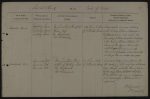
| < | List of Names as written on the Plan |
Various modes of Spelling the same Names |
Authority for those modes of Spelling |
Situation | Descriptive Remarks, or other General Observations which may be considered of Interest |
> |
|---|---|---|---|---|---|---|
| Foulplay Head | Foulplay Head | McLauchlan’s Plan of the | 64 Chains E.S. East | A considerable eminence situated | ||
| Roman Way | of Cottonshope Head | on the division between Cottonshope & | ||||
| Foulplay Head | Mr. Hindmarsh | Featherwood Moors, over which the | ||||
| Foulplay Head | Mr. Drummond | boundary between Holystone Chapelry | ||||
| & the Parish of Elsdon extends. The | ||||||
| Course of the Roman Road also | ||||||
| extends over this eminence the | ||||||
| Summit of which is marked with | ||||||
| a large Roman entrenchment. | ||||||
| Gammel’s Path | Gammel’s Path | McLauchlan’s Plan & | 74 Chains North | A natural Vally or pass formed by | ||
| Memoir of Watling Street | of Cottonshope Head | the meeting of Thirl Moor Edge with Harden | ||||
| Gammel’s Path | Mr. Hindmarsh | Edge through which the Roman road & | ||||
| Gammel’s Path | Mr. Drummond | the boundary between Holystone Chapelry, & | ||||
| Elsdon passes. This name is Supposed | ||||||
| to be derived from the Danish word | ||||||
| Gammel. | ||||||
| J. Doherty Lance Corporal Royal Engineers |
Abbreviations are underlined like this RE and the expansion may be seen by hovering the cursor over the abbreviation.
| An entry outlined like this has a note which may be seen by hovering the cursor over it. |
Transcribed by RP
Return to Elsdon 365 index