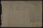
| List of Names as written on the Plan |
Various modes of Spelling the same Names |
Authority for those modes of Spelling |
Situation | Descriptive Remarks, or other General Observations which may be considered of Interest |
> | |
|---|---|---|---|---|---|---|
| Carter Fell | Carter Fell | Mr Thompson | 20 chains West of | A large Mountain of Considerable | ||
| Carter Fell | Mr Dodd | Black Cleugh | elevation. Situated at the North Western | |||
| Carter Fell | Mr Oliver | extremity of the Parish of Elsdon over | ||||
| Extracts from White’s directory | which the boundary between England & | |||||
| Scotland extends. The North East end | ||||||
| of this Hill is about 1/4 Mile West of the | ||||||
| Turnpike Road leading from White Lee | ||||||
| to Carter Toll Bar and extends in a | ||||||
| South Westerly direction to within about | ||||||
| 1/2 Mile of the point when the boundary | ||||||
| of the parishes of Elsdon & Falstone joins | ||||||
| that of Scotland. |
||||||
| J. Doherty Lance Corporal Royal Engineers |
Abbreviations are underlined like this RE and the expansion may be seen by hovering the cursor over the abbreviation.
| An entry outlined like this has a note which may be seen by hovering the cursor over it. |
Transcribed by RP
Return to Elsdon 365 index
(This is the first page) Next page»