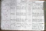
| < | List of Names as written on the Plan |
Various modes of Spelling the same Names |
Authority for those modes of Spelling |
Situation | Descriptive Remarks, or other General Observations which may be considered of Interest |
> |
|---|---|---|---|---|---|---|
| Greystone Burn | Greystone Burn | J.F. Carr farmer Titlington Mount | On Sheets | A small stream rising on the E. of Titlington | ||
| John Davison Esqr. Shawdon Hill | 31.1 & | Pike, and passing Titlington Mount joins | ||||
| Estate map of W.J. Pawson Esqr. | 31.5 | Titlington Burn, to the S. by E. – | ||||
| Titlington | Titlington | W.J. Pawson Esqr. Titlington Hall | On Sheet | A Farmhouse with offices & hamlet, also | ||
| John Davison Esqr. Shawdon Hill | 31.5 | a township, in Eglingham Parish, about 3/4 | ||||
| Estate map of W.J. Pawson Esqr. | of a mile N.E. of Shawdon Hall, the property | |||||
| of W.J. Pawson Esqr. – | ||||||
| Titlington Hall | Titlington Hall | W.J. Pawson Esqr. Resident – & Proprietor | On Sheet | A neat modern mansion adjoining | ||
| John Davison Esqr. Shawdon Hill | 31.5 | Titlington farmhouse – The seat, and | ||||
| F. Harbottle farmer Titlington | occasional residence of W.J. Pawson Esqr. – | |||||
| Camp | Camp | Ralph Carr Esqr | On Sheet | The remains of a British [or] | ||
| (Remains of) | (Remains of) | Hedgeley | 31.3 | perhaps Saxon Camp. | ||
| Armstrong’s Map 1769 – | Situated on the North side | |||||
| of Eglingham Burn & a little | ||||||
| to the East of Shipleymoor – | ||||||
| Robt Young Corporal Royal Engineers |
Note: Signed in header ('Described by')
Abbreviations are underlined like this RE and the expansion may be seen by hovering the cursor over the abbreviation.
| An entry outlined like this has a note which may be seen by hovering the cursor over it. |
Transcribed by PT and PF
Return to Eglingham index