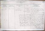
| < | List of Names as written on the Plan |
Various modes of Spelling the same Names |
Authority for those modes of Spelling |
Situation | Descriptive Remarks, or other General Observations which may be considered of Interest |
|
|---|---|---|---|---|---|---|
| River Till | River Till | County Map | On Sheet | A river which has its source or rise in | ||
| Whites Directory | 14.11 | the Eastern part of the Cheviot Hills | ||||
| 14.12 | in the Parish of Ilderton about 4 miles | |||||
| 14.16 | South of Wooler | |||||
| not written | 15.13R | |||||
| 20.1 | From this point it proceeds in a N.Easterly | |||||
| direction for about 4 miles to Haggis Hall, where it receives the waters of the | ||||||
| River Beamish, it then proceeds Northwardly for about 4 miles to Lyham; | ||||||
| at this point it turns westward for about 4 miles to near Weetwood Hall | ||||||
| where it receives the "Wooler Water"- it then proceeds in a generally | ||||||
| N.W. direction for about 2 Miles where it receives the water of the | ||||||
| River Glen, which river is formed by the united streams of the | ||||||
| Continues in the same general direction, past Ford, Etal & | ||||||
| enters Norham Parish near to New Etal & empties itself into the | ||||||
| River Tweed about a mile West of Twizell Castle | ||||||
| R. Burnaby | ||||||
| Major RE | ||||||
| 30 June 1860 | ||||||
| W. Beatty | ||||||
Abbreviations are underlined like this RE and the expansion may be seen by hovering the cursor over the abbreviation.
| An entry outlined like this has a note which may be seen by hovering the cursor over it. |
Transcribed by PW and CTW
Return to Doddington 359 index
«Previous page (This is the last page)