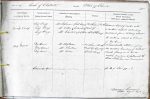
| < | List of Names as written on the Plan |
Various modes of Spelling the same Names |
Authority for those modes of Spelling |
Situation | Descriptive Remarks, or other General Observations which may be considered of Interest |
> |
|---|---|---|---|---|---|---|
| Long Crag | Long Crag | Mr. Stephenson (Colt Crag) | 28 Chains South | Scattered ledges of rocks with | ||
| Long Crag | Mr. Willis (Colwell) | east of | a northern aspect extending | |||
| Long Crag | Mr. Charlton (Sooty Row) | Colt Crag | eastward from Watling Street | |||
| to within about 10 Chains | ||||||
| of Dry Burn | ||||||
| Dry Burn | Dry Burn | Mr. Stephenson | 35 Chains South | A considerable Stream forming | ||
| Dry Burn | Mr. Charlton | east by East of | the eastern boundary of Chollerton | |||
| Dry Burn | Mr. Willis | Colt Crag | Parish flowing in a South | |||
| easterly direction & falling into the | ||||||
| River North Tyne near Barrasford | ||||||
| Gunnerton Burn | See NB of Sheet 77-1 | |||||
| Duncan Cameron Sapper Royal Engineers |
Abbreviations are underlined like this RE and the expansion may be seen by hovering the cursor over the abbreviation.
| An entry outlined like this has a note which may be seen by hovering the cursor over it. |
Transcribed by PT
Return to Chollerton index