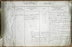
| < | List of Names as written on the Plan |
Various modes of Spelling the same Names |
Authority for those modes of Spelling |
Situation | Descriptive Remarks, or other General Observations which may be considered of Interest |
> |
|---|---|---|---|---|---|---|
| River Tweed | River Tweed | Map of Northumberland | On sheets | The popular and the really remotest source | ||
| Map of Berwickshire | 8.A.16 | of the Tweed is a healthy fountain called | ||||
| Map of Roxburghshire | 9.9 | Tweed’s-well, a little above the farm house | ||||
| 9.10 | of Tweedsmuir, and at the foot of a hill | |||||
| 9.11 | called Tweed’s-cross on the south western | |||||
| 9.13 & | boundary of the parish of Tweedsmuir | |||||
| 9.15 | Peeblesshire 1500 feet above the level of | |||||
| the sea. | ||||||
| From its remotest sources to the sea at | ||||||
| Berwick upon Tweed, it performs, irrespectively | ||||||
| of windings, a run of about 100 miles & drains | ||||||
| 1870 square miles. | ||||||
| There is no regular Navigation of the River Tweed above Berwick Bridge by vessels | ||||||
| larger than Fishing Cobles. No Vessel of 50 tons burthen could get over South Bells | ||||||
| Ford opposite West Ord House at any time. | ||||||
| The ordinary Spring Tides flow to the west end of St Thomas’ Island, about | ||||||
| half a mile above Horncliffe and about twice a year the Springs nearest the | ||||||
| Equinoxes flow as high as Norham Castle | ||||||
| W. Beatty | ||||||
Note: Signature in header
Abbreviations are underlined like this RE and the expansion may be seen by hovering the cursor over the abbreviation.
| An entry outlined like this has a note which may be seen by hovering the cursor over it. |
Transcribed by BER
Return to Carham index