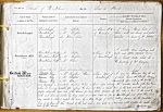
| < | List of Names as written on the Plan |
Various modes of Spelling the same Names |
Authority for those modes of Spelling |
Situation | Descriptive Remarks, or other General Observations which may be considered of Interest |
> |
|---|---|---|---|---|---|---|
| Brinkheugh | Brinkheugh | Mr Stoker | 40 Chains |
A Farm House built of | ||
| Brinkheugh | Mr Leighton | of Tumulus | stone with out-houses and garden | |||
| Brinkheugh | Co Voters List | attached occupied by Mr Stoker | ||||
| Brinkburn Mill | Brinkburn Mill} | Mr Stoker | 20 Chains S.W. | A small stone building with | ||
| (Corn) | Brinkburn Mill} Corn | Mr Leighton | of Brinkheugh | mill and stables attached driven | ||
| Brinkburn Mill} | Mr Coxon | by a breast water wheel It is | ||||
| the property of Mrs Cadogan | ||||||
| British Way | Ancient Way | McLauchin’s trace of Roman Road | 1 Chain West of | |||
| Mc Laughlin’s Plan | Brinkheugh | A narrow |
||||
| (Remains of) | Mr Leighton | of which leaves the Devils Causeway | ||||
| Mr Coxon | immediately after entering the parish | |||||
| and passing in a westerly direction takes a bend | ||||||
| before entering the wooded banks of the Tod Burn | ||||||
| where it is very visible, after crossing the burn | ||||||
| it takes a sharp turn to the east and the site of it | ||||||
| passes along the west side of the stream for some | ||||||
| little distance. It then takes a turn to the west |
||||||
| north and becomes visible by being used as | ||||||
| a cart road as far as Brinkheugh and from there it is | ||||||
| very visible to where it crossed the river by a stone Bridge | ||||||
| of which nothing remains but the foundation | ||||||
| of one of its piers. It then turned to the east and is | ||||||
| now used as a cart road until it enters the |
||||||
| side of the Camp | ||||||
| Alfred Brittain SRE | ||||||
Abbreviations are underlined like this RE and the expansion may be seen by hovering the cursor over the abbreviation.
| An entry outlined like this has a note which may be seen by hovering the cursor over it. |
Transcribed by PAF and AOS
Return to Brinkburn index