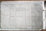
| < | List of Names as written on the Plan |
Various modes of Spelling the same Names |
Authority for those modes of Spelling |
Situation | Descriptive Remarks, or other General Observations which may be considered of Interest |
> |
|---|---|---|---|---|---|---|
| Burrows Hole | Burrows Hole | Admiralty North Sea Pilot Guide | On Sheet | The channel between ‘Parton Stiel’ and ‘Long | ||
| Burrows Hole | Mr. Ralph Wilson; Harbour Master H.I. | 12.7 | Ridge’, extending from the Harbour Bar – which | |||
| Burrows Hole | Mr. Wm Bowey, Keeper, Old Law | lies betwixt ‘Parton Stiel’ and ‘Ridge End’. – | ||||
| Burrows Hole | Mr R Stamp, Schoolmaster H.I | to near ‘Law Scap’ on the west, and the ‘way’ | ||||
| so narrow and the bottom |
||||||
| only ships in a great strait will anchor in it. | ||||||
| Parton Stiel | Parton Stiel | Same authorities | On sheets | A point at Low Watermark, at the south end | ||
| 12.7 & | of the bar entrance to Holy Island Harbour, | |||||
| 12.11 | near ‘Burrows Hole’, formed of sand, boulders, | |||||
| a few flat or surface rocks, and sea weed, | ||||||
| and a dangerous place to ships in a gale | ||||||
| that miss the Bar, – many vessels having been | ||||||
| wrecked upon it; Off it Crab fishing is much followed. | ||||||
| Dollar Banks | Dollar Banks | Same authorities | On sheet | Sand banks on ‘Old Law’ to the west of ‘Parton | ||
| 12.11 | Stiel’ on which some foreign ship having | |||||
| been wrecked, a number of dollars were washed | ||||||
| upon these banks, which are now named | ||||||
| after the Coin found on them. | ||||||
Note: Unsigned
Abbreviations are underlined like this RE and the expansion may be seen by hovering the cursor over the abbreviation.
| An entry outlined like this has a note which may be seen by hovering the cursor over it. |
Transcribed by KF
Return to Belford index