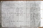
| < | List of Names as written on the Plan |
Various modes of Spelling the same Names |
Authority for those modes of Spelling |
Situation | Descriptive Remarks, or other General Observations which may be considered of Interest |
> |
|---|---|---|---|---|---|---|
| Links End | Links End | Admiralty chart | On seat | The south end of Ross | ||
| Links End | Mr. William Hardie | 16.3 | Links, |
|||
| Links End | County Map | ley Bottoms" and Ross | ||||
| Links End | William Bowey | Back Sands | ||||
| Ross Back Sands | Ross Back Sands | On sheets | Embraces all th | |||
| Ross Back Sands | William Hardie | 12.11 | sand between High, and | |||
| Ross Back Sands | William Bowey | 12.15 | Low Water mark |
|||
| 16.3 & | water, |
|||||
| 16.4 | Budle Water, on the south | |||||
| and southeast of Ross town | ||||||
| ship, It is hard sand | ||||||
| when the Tide is out. | ||||||
| Sand Ridge | Sand Ridge | J Bolam Esqr | On sheets | An elevated portion | ||
| William Hardie | 16.3 & | of "Ross Back Sands," near | ||||
| William Bowey | 16.4 | Low Water Mark, extending | ||||
| in a northwest direction for | ||||||
| about 3/4 of a mile from where | ||||||
| +2This ridge is very dangerous to | Budle Water discharges itself | |||||
| +2shipping & several wrecks occur | into the sea at low water. | |||||
| +2on it. | ||||||
Note: Unsigned
Abbreviations are underlined like this RE and the expansion may be seen by hovering the cursor over the abbreviation.
| An entry outlined like this has a note which may be seen by hovering the cursor over it. |
Transcribed by KF
Return to Belford index