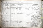
| < | List of Names as written on the Plan |
Various modes of Spelling the same Names |
Authority for those modes of Spelling |
Situation | Descriptive Remarks, or other General Observations which may be considered of Interest |
> |
|---|---|---|---|---|---|---|
| Southrock End | Southrock End | Admiralty Chart | On Sheet | A narrow point, of the rocks | ||
| Southrock End | Mr. M. Robson | 17.14 | at low water mark, on the | |||
| Southrock End | Mr. Wm. Swan | south side of "Lowgos Bay" | ||||
| Mr. John Patterson | and northeast of Pace Hill. | |||||
| Pace Hill | Pace Hill | Admiralty Chart | On Sheet | A narrow, oblong rock, | ||
| Mr. M. Robson, Fisherman | 17.14 | of considerable elevation, | ||||
| Mr. Wm. Swan | and partially covered with | |||||
| Mr. John Patterson | grass. |
|||||
| flat rocks, about 20 chains S.E. | ||||||
| of the harbour, at "Sea Houses". | ||||||
| It is never covered, even at the | ||||||
| highes tides, (Origin of name | ||||||
| unknown). | ||||||
| Braidstone Hole | Braidstone Hole | Mr. John Patterson | On Sheet | A small creek, in the | ||
| Braidstone Hole | Mr. M. Robson | 17.14 | rocks, at low water, a short | |||
| Braidstone Hole | Mr. Wm. Swan | distance south of Pace Hill. | ||||
| The rocks, in this creek, are | ||||||
| broad, and flat, hence the | ||||||
| name Braidstone. | ||||||
Note: No heading; unsigned
Abbreviations are underlined like this RE and the expansion may be seen by hovering the cursor over the abbreviation.
| An entry outlined like this has a note which may be seen by hovering the cursor over it. |
Transcribed by HL
Return to Bamburgh index