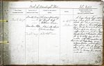
| < | List of Names as written on the Plan |
Various modes of Spelling the same Names |
Authority for those modes of Spelling |
Situation | Descriptive Remarks, or other General Observations which may be considered of Interest |
> |
|---|---|---|---|---|---|---|
| Budle Bay | Budle Bay | Whellan’s Directory | On Sheet | A large Sandy bay, extend- | ||
| Budle Bay | Mr. Hugh Ross | 16.4 | ing inland from low water | |||
| Budle Bay | Mr. William Carr | Mark, for about 1 1/2 miles. | ||||
| Warnham Flats | Admiralty Chart | And extends in breadth, |
||||
| Warnham Flats | District Map | from ‘Budle Point’, to ‘Ross Links, | ||||
| Budle Bay | Adopted | Portions of it, are, known by | ||||
| different names, such as Ross | ||||||
| Back Sands, & Chesterhill Slakes. | ||||||
| It is Completely dry, at low | ||||||
| water, with the exception of | ||||||
| the waters of Ross Low, And | ||||||
| Waren Burn, which flow | ||||||
| through it, but at spring tide | ||||||
| there is from 4 to 7 fathoms | ||||||
| water in it, – very few vessels | ||||||
| enter it. | ||||||
| John McCabe |
Note: Signature in header
Abbreviations are underlined like this RE and the expansion may be seen by hovering the cursor over the abbreviation.
| An entry outlined like this has a note which may be seen by hovering the cursor over it. |
Transcribed by HL and DW
Return to Bamburgh index