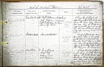
| < | List of Names as written on the Plan |
Various modes of Spelling the same Names |
Authority for those modes of Spelling |
Situation | Descriptive Remarks, or other General Observations which may be considered of Interest |
> |
|---|---|---|---|---|---|---|
| Greenhill Rocks | Greenhill Rocks | Mr. Robt Patterson (Monkshouse) | On Sheets | A large bed of flat Rocks | ||
| Greenhill Rocks | Mr. John Patterson – N. Sunderland | 17.5 | extending, about |
|||
| Greenhill Rocks | Mr. Robt Cuthbertson (Sea Houses) | 17.9 | along the Shore, they have a | |||
| Admiralty Chart | bold edge, along the South Side | |||||
| dipping gradually to the north. | ||||||
| There are, Several Small breaks, | ||||||
| across them, Running nearly east & S. | ||||||
| west. | ||||||
| Islestone | Isleston |
Mr. Robt Patterson (Monkshouse) | On Sheet | A Mass of flat rocks, and | ||
| Mr. John Patterson – N. Sunderland | 17.5 | Boulders, Close to Low Water | ||||
| Mr. Robt Cuthbertson (Sea Houses) | Mark About 1/2 a mile north of | |||||
| Admiralty Chart | "Greenhill Rocks", there is a bold | |||||
| edge, along the Southeast Side – | ||||||
| dipping gradually to the north – | ||||||
| where they join Low Water. | ||||||
| Bowl Hole | Bowl Hole | Mr. James Dunse | On Sheet | A large Circular hollow – | ||
| Bowl Hole | Mr. Hugh Ross | 17.5 | in the Sand, And on the boundary | |||
| Bowl Hole | Mr. William Carr | between the "Castle Links", And | ||||
| Bowl Hole | Mr. Robt Patterson. | "Redbarns Links". It was a very deep | ||||
| hole, filled with water, but is now | ||||||
| Completely Sanded up. The Name, | ||||||
| was given to it, from its Bowl | ||||||
| Like Shape. | ||||||
| John McCabe |
Note: Signature in heading
Abbreviations are underlined like this RE and the expansion may be seen by hovering the cursor over the abbreviation.
| An entry outlined like this has a note which may be seen by hovering the cursor over it. |
Transcribed by HL and DW
Return to Bamburgh index