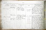
| < | List of Names as written on the Plan |
Various modes of Spelling the same Names |
Authority for those modes of Spelling |
Situation | Descriptive Remarks, or other General Observations which may be considered of Interest |
> |
|---|---|---|---|---|---|---|
| Cock Ridge | Cock Ridge | Tithe Map | On Sheet | A hill feature in an arable | ||
| Cock Ridge | Mr. John Archbold | 21.3 | field on Lucker Southfarm | |||
| Cock Ridge | Mr. Thomas Paxton | |||||
| of the farmhouse. This is sup | ||||||
| posed to have been, where an | ||||||
| open Common, much frequented | ||||||
| by moor fowl – (hence the name) | ||||||
| Waren Burn | Waren Burn | P.Selby Esqr. Twizell Ho. | On Sheets | A considerable stream, having | ||
| Waren Burn | George Selby Esqr. Alnwick | 16.3 | its source in the moors, of Chatton | |||
| Waren Burn | Revd M. Thompson. | 16.7 | & forms the boundary, between, that | |||
| Warren Burn | A. Hills Esqr. Howick | 16.11 | parish, and the parish of Bamburgh | |||
| Warn Burn | County Map | 16.15 | for a short distance – then flowing | |||
| 21.3 | eastward past Twizell House, through | |||||
| 21.6 & | Warenford, thence to to Lucker, | |||||
| 21.7 | where its water supplies a Cornmill | |||||
| after which it flows past Bradford, | ||||||
| thence to Spindleston, where ano- | ||||||
| -ther good Mill is erected and | ||||||
| which it also supplies with | ||||||
| Water, and finally empties itself | ||||||
| into Budle Bay – at Waren | ||||||
| Mill – after which, |
||||||
| Budle Water. | ||||||
Note: No heading; unsigned
Abbreviations are underlined like this RE and the expansion may be seen by hovering the cursor over the abbreviation.
| An entry outlined like this has a note which may be seen by hovering the cursor over it. |
Transcribed by HL
Return to Bamburgh index